Where
Location
The site lies 1km south east of the town of Kington, close to the suburb of Headbrook and adjacent to the A4111 road, in Herefordshire, Post code HR5 3EA.

Figure 1: Kington Medical Centre entrance
Description
The development was built on greenfield land and is approximately 0.8 hectares in size; this includes the health centre, car parks and associated landscape. The land slopes from 164.5m AOD beside the A4111 in the south west of the site to 160.3m AOD in the north east of the site where the water is discharged into the nearby Head Brook.
The landscape around the site is generally agricultural with scattered farms and woodland, with the town of Kington to the northwest. Along the eastern boundary lies the Head Brook, a tributary of the River Arrow which it meets approximately 600m north of the site. The channel flows south to north and is characterised by high banks, along which grow a number of mature trees with some understorey shrubs.
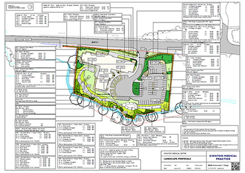
Figure 2: Landscape Design (click to enlarge)
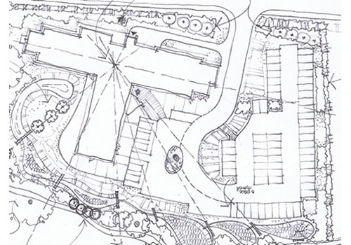
Figure 3: Landscape proposals
Main SuDS used
The aim was to create a functional, diverse and low-maintenance SuDS scheme (the wetland is just one of the many components used) wetland system adjacent to the existing brook to protect the brook from stormwater discharge from the development site and pollution. Through the design of the SuDS it was important to protect existing landscape features and to create habitat for wildlife.
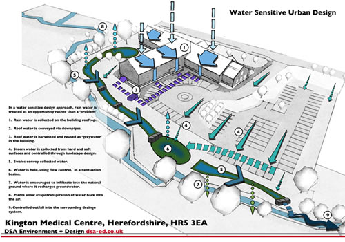
Runoff is collected from the building roof and paved areas via a network of pipes and stored within a rainwater harvesting tank, from where water is then pumped into the building to flush toilets. Any overflows are directed into a series of swales.
Figure 4: Illustrated SuDS diagram showing the movement of water through the site (click to enlarge)
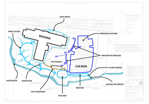
Figure 5: The Drainage Layout
How it works
A ‘SuDS’ approach to storm water was adopted. This involved developing a ‘treatment train’ that uses permeable pavements and infiltration trenches to promote infiltration. The design is focused around a series of open swales that feed into a wetland system; the lower part of which is a reed bed. These treatment stages are separated by gabion baskets and filter and infiltrate the water before eventually discharging it into the brook at greenfield runoff rates. Stone pitching bank protection measures were installed to prevent erosion of the existing banks of the brook. The swales are very shallow and have carefully graded side slopes to enable mowing.
The primary landscape structure was drawn from the analysis of the site context and in particular the strong influence of the existing stream corridor and hedgerow along the southern side of the site. It contains outfall, inlet and wet structures as part of the SuDS treatment train. Surface water was discharged into brook at greenfield runoff rates (Max 5l/s) as approved by the Environment Agency.
All of the SuDS were designed for a critical 100 year + climate change storm event in accordance with BREEAM requirements. Swales were designed with a curvilinear contoured form typically 1:5 max gradient to create a softer appearance and to enable mowing.
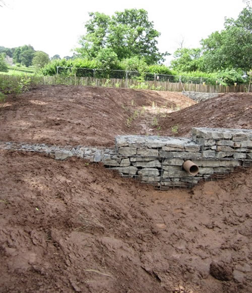
Figure 6: The treatment train of open swales and wetlands, separated by gabion baskets, filtering and infiltrating the water before discharging into the brook (During construction).

Figure 7: The swales were graded to be very shallow to enable mowing (During construction).

Figure 8: Outside the wetlands, the grassland is longer and receives a lighter management treatment. Wildflower grass mixes were used in the more peripheral areas and conventional grass mixtures were used on the lawns.
Specific details
The landscape design involved the creation of areas of new, chiefly native, planting and grassland as well as a series of wetlands acting as part of the storm-water management system on the site.
The wetlands are planted with marginal aquatics including grasses, sedges and rushes, and seeded with a wildflower grass seed mix. Mentha aquatica (Water mint), Myosotis scorpioides (Water forget-me-not) and Phalaris arundinacea (Reed canary grass) are some of the species used.
Outside the wetlands, the grassland is longer and receives a lighter management treatment appropriate to the ‘wet meadow’ setting. Wildflower grass mixes were used to start to establish a broad range of species in the more peripheral areas. More conventional grass mixtures were used on the lawns. Riparian woodland species have been planted along the stream bank. Employees and patients of the Health Centre are able to enjoy the landscape, including the swales that are located in the staff gardens; however, the wetland is located below the car park and has a post and rail fence restricting access.
Native shrubs set into groundcovers are used to ‘knit’ the planting scheme into its context. Within the site, extensive areas of grassland punctuated by specimen trees, give a strongly unified theme.
A new otter holt was built within the native woodland block at the southern end of the site, close to the river. Otters are known to use the stream corridor and this feature was intended to augment existing laying-up points north and south of the site.
The permeable paving car park has a 375mm thick modified Type 1 granular sub base with fines less than 5mm removed.
A Landscape Management Plan was conditioned by Herefordshire County Council.

Figure 9: Rain chains were used by the architects to create an interesting feature using rainwater runoff.

Figure 10: The wetlands are planted with marginal aquatics including grasses, sedges and rushes, and seeded with a wildflower grass seed mix.

Figure 11: The new otter holt was built within the native woodland block at the southern end of the site, close to the river.
Benefits or achievements
-
Wetland features manage runoff to ensure clean water enters the natural drainage system.
-
Savings in cost of installation over a conventional piped or underground drainage..
-
Massive biodiversity increase on a site that had no wetland before.
-
No oil interceptors, water treated biologically.
-
Water is treated biologically through the system and released back into the stream.
-
Positive example of sustainable design. Through the use of a rainwater-harvesting tank a volume of water is kept out of the storm-water management system, this is known as interception and helps to reduce the flooding risk.
Challenges or lessons learned
-
Care needed to avoid contamination of the river system.
-
Close contact with contractors was needed.
-
In between the development and the stream, a transitional zones of wetland and dry swales is formed that will require a much lighter management touch.
Team and details
Client: Kington Medical Practice, Dr Richard King
Main Contractor: Vinci Construction UK Ltd, Graham Thomas.
Landscape Architect: DSA Environment & Design, David Singelton
Engineer: Couch Consulting Engineers, Nicola Karmelita
Architect: West Hart Partnership, Jim Hart, Justin Jones, Ian Humphries
M+E Services Engineer: ESC, James Tickle
QS/PM: Carl Dean Associates
Local Authority: Herefordshire County Council Planning Officer: Andrew Banks
Status: Completed 2012
For more details contact: DSA 0115 981 8745 www.dsa-ed.co.uk
Reviewed May 2014


