Where
Location
Located in the London Borough of Tower Hamlets, Derbyshire Street runs in an east/west direction, parallel with Bethnal Green Road, E2 6HG.
Description
The eastern end of Derbyshire Street was a dead end section of the public highway. Its primary use was for parking, however with no turning head, minor accidents were frequent and motorists avoided using the space. Being a dead end, with large trees and fencing surrounding the street, fly tipping and anti-social behaviour were common.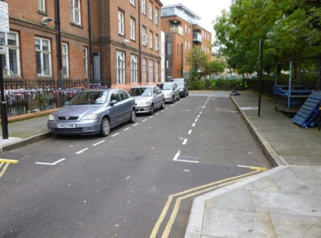
Figure 1: Photograph of Derbyshire Street looking eastbound June 2013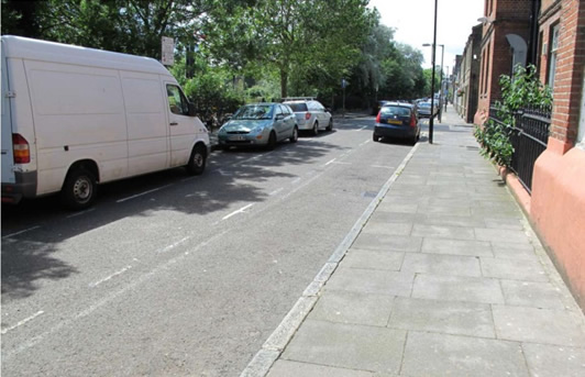
Figure 2: Photograph looking westbound from Weaver Fields June 2013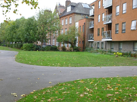
Figure 3: Photograph looking westbound from Weaver Fields June 2013
The project resulted from the proposed installation of a new cycle route as well as working with Oxford House to create a new outside space for community events. The project was submitted to the Mayor of London’s Pocket Park Programme in 2013 and won the highest amount of funding for that year.
The aim of the scheme was to create a useable and sustainable space, with specific objectives including:
- Create a new east/west link from Derbyshire Street to Viaduct Place, making it an accessible connective route
- Use of SuDS (Sustainable Drainage Systems) so all surface water naturally drains away and no surface water would enter the combined sewer system
- To promote SuDS in Tower Hamlets, and use the scheme as a case study for developers, showing how SuDS can be implemented into the urban environment
- Upgrade the lighting stock and use energy efficient LED lighting
- Create a new cycle lane and cycle storage facilities
- Create a space that can be used for community and art events
- Use native and nectar rich plants
- Plant edible herbs and fruit trees in an attempt to spread the word of “grow your own”
- Use recycled materials
- Create a secure space for on street bin storage
Main SuDS used
The pocket park disconnects the east end of Derbyshire Street from the combined sewer system with all surface water dealt with on site. There are six SuDS components used in the pocket park: attenuating planters, permeable paving, small scale green roofs, rain gardens, engineered tree pits and a swale. Below all the SuDS features are listed in more detail, including construction and maintenance and Figures 4 – 7 show the proposed SuDS scheme.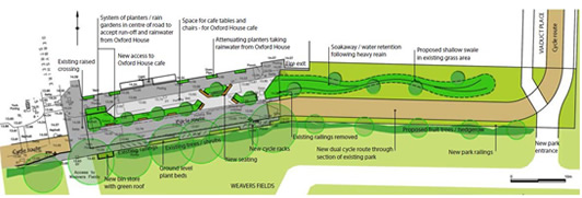
Figure 4: Derbyshire Street proposed layout (click to enlarge)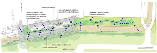
Figure 5: proposed location of SuDS and catchment design (click to enlarge)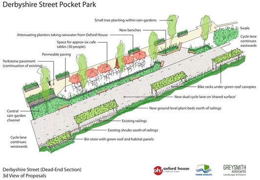
Figure 7: Visualisation of the proposals (click to enlarge)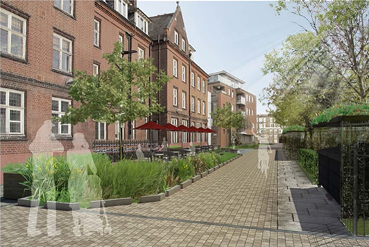
Figure 8: Connecting the overflow chamber of the attenuating planters to the rain garden via a clay pipe
Attenuating rain water planters
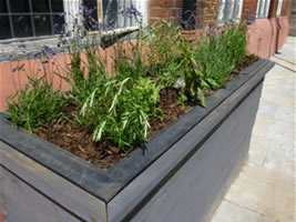
Amount of water storage: 3m3
Construction details: Made from plastic, with a wooden façade, the planting trays are 8 inches in depth to support growth of small plants, lined with hessian to prohibit soil washing into the tanks. The water storage tank holds 1m3 of water and is set into the surrounding York stone to provide stability and room for the overflow pipe underground. Down pipes from Oxford house are disconnected and piped into the back of the planters.
Maintenance: Tanks cleared out annually and plants weeded bi-annually. Summer watering of plants may be necessary.
Additional information: Donated by TWU. Constructed by LJ Plastics.
Permeable block paving 45m2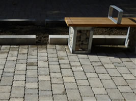
Amount of water storage: 4.6m3
Construction details: The permeable blocks are laid on a permeable sub-base. The paving is on a slight gradient so that water is conveyed into the rain garden. There is a perforated pipe at the highest point of the permeable paving, which acts as an exceedance route, if the system becomes saturated. The pipe runs to a gully pot.
Maintenance: Ad-hoc Sweeping by the street cleaners.
Additional information: Permeable paving from Marshalls. Can be used with underground geocellular storage crates.
Rain gardens and tree pits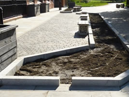
Amount of water storage: 4.12m3 for large rain garden and 3.09m3 for the smaller rain garden
Construction details: 1m to 1.2m in depth. 500-600mm of gravel and shingle, with 500mm of rain garden soil consisting of approximately 45% sand, 40% silt, 10% clay and 5% organic matter.
Maintenance: Inlets (spacing between kerbs) need to be kept clear of litter. Weeded three times a year. A wood chip mulch was used for weed suppression and to help retain consistent moisture levels
Small scale green roofs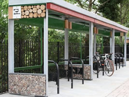
Amount of water storage: 0.6m3
Construction details: The roof is approximately 100mm in depth and has a gutter and down pipe at the rear for overflow. The roof is planted and habitat panels are used around the structure.
Maintenance: As it was installed in the summer, the green roof had to be watered for a few weeks. Annual inspection of the structure, roof and guttering is required.
Additional information: Designed and constructed by Green Roof Shelter Ltd.
Swale
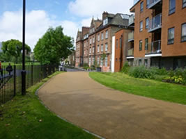
Amount of water storage: Below the surface 9.02m3 and in the basins above ground 2.00m3
Construction details: 1m in depth with 500mm of gravel and 500mm of rain garden soil. As the swale was turfed, it was compacted.
Maintenance: The swale is mowed every 3 weeks in the summer and every 4-6 weeks in the winter.
The SuDS have been blended into the scheme, with the central rain garden and tree pits acting as a pathway through the scheme, linking all the components together. Due to the scale of scheme and lack of space, source control was critical, with all water having to be dealt with on-site.
Water is collected from the roof of Oxford House in the attenuating rainwater planters, when at saturation point an overflow point discharges excess water under the footway and permeable paving and into the rain garden, shown in Figure 8. 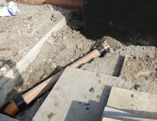
Figure 8: Connecting the overflow chamber of the attenuating planters to the rain garden via a clay pipe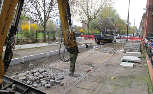
Figure 9: Original road bed revealed for rain garden and pipe connection routes to be created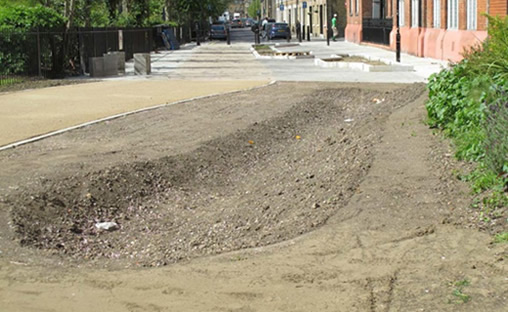
Figure 10: The swale formed
When the storage space under the permeable paving is at saturation point, the surplus water flows into the rain garden. The same process happens for the green roof bike shelters and bin shelters. All impermeable surfaces are drained into the rain gardens. This is done using a slight gradient, with all of Derbyshire Street gently sloping towards the central rain garden (Figures 11 and 12). The two rain gardens and tree pits are linked by an underground clay pipe, so water can move from the large rain garden to the small one when at saturation. The small rain garden is finally linked to the swale, again through an underground pipe. Additional roof water from Oxford House is disconnected and discharged into the swale. The swale is designed so that water is stored below the surface and once saturated it ponds on the surface in two discrete small basins. Where these reach capacity there is an exceedance point which is connected to a conventional gully. It should be noted that infiltration is encouraged at Derbyshire Street with no part of the SuDS scheme lined with geotextile. 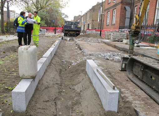
Figure 11: Lining up the rain gardens. Working back from the lowest point to attain enough fall, November 2013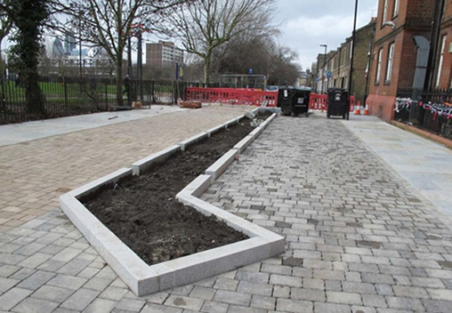
Figure 12: Completion of hard works, February 2014
The scheme is not designed for a specific return period, but to hold as much water as possible without detriment to the design and practical function of the pocket park. The scheme is able to hold approximately 25m3 of surface water, including the volumetric water storage capacity at field capacity. When the total void porosity is calculated the water storage volume at field capacity is subtracted from the void space to give a more realistic value of water storage. From back calculating this means it can work to 1:100 year event easily, with runoff rate calculated between 5-6 l/s. To date no water has ponded in the swale, which is the final part of the SuDS train. It has dealt with the winter of 2013/14 and flash summer floods in 2014. During a heavy rainfall event water can be seen at the inlets to the rain garden, especially on the impermeable surfaces, however within 5 minutes of rainfall ceasing, the water has drained into the rain garden.
As the Pocket Park caters only for pedestrians and cyclists, no specific water quality measures were put in place. However due to the number of SuDS stages, it’s thought that improvements in the quality of surface water would happen naturally, as surface water moves through the system.
Specific details
The space had to be multifunctional, working as a seating area, cycle lane, as well as a space for community events and activities. It is accessible 24 hours a day.Raised kerbs around the rain garden help with accessibility for partially sighted users and improved street lighting and CCTV allow the space to be utilised at night.
Biodiversity improvements were achieved through planting and making subtle adjustments in standard highway design. The green roof bike shelters and bin shelters have habitat panels that provide nesting sites for bees, insects and birds.
Materials have been recycled and reused on-site: the excavated granite setts from the road have been reused in the gabion seating; crushed concrete and aggregates in the ballast on the green roof shelter; and large granite blocks (previously used as bollards) have been used to create a “mini Stonehenge”, providing some additional seating but also a small play feature.
The cost of the SuDS in comparison to a normal drainage scheme is not comparable in this instance as the drainage was already on-site. However the cost of paving the area rather than creating the rain garden and swale, would have been much higher. The total cost of the pocket park was £120,000. It should be noted that high end materials were used throughout, such as York stone and granite kerbs. Installation of the cycle lane and highway improvements to the remainder of Derbyshire Street (road widening) came to £60,000. The maintenance costs of the SuDS are also low. The swale is mowen in the summer and the planted areas are weeded and cared for by a local volunteering group (Figure 14.) To date no vandalism has been noted, with no plants or trees being stolen.
Benefits and the future
- No water goes into the combined sewer system. It is all dealt with on-site, thus mitigating local flood risk from surface water run-off, encouraging natural drainage and feeding water back into the water cycle
- Enhanced biodiversity through nectar rich, native planting and the habitat panels (bees and butterflies have been seen in the rain garden and near the panels)
- Use of energy efficient LED lighting
- Reuse of materials on site
- Creation of a sign board which shows the flow path of surface water throughout the scheme, but importantly it also shows the alternative, with water entering the sewer system. It is hoped that residents and developers will understand the importance of SuDS and how these can be integrated into the smallest of spaces.
- The future of the Pocket Park is in the hands of the local residents and community groups. The scheme has been promoted as “Derbyshire Street Pocket Park” to emphasise a place rather than a SuDS or highways scheme. The first community event was held in September 2014, celebrating 130 years of Oxford House with the area’s first ever street party held in the pocket park (Figure 20).
Lessons learnt
- Permeable block paving might look unsightly when cigarette ends get logged in the spacing between the blocks. Using a porous block or surfaces could be a solution
- Underground apparatus was minimal and as such, no issues arose due to services. However service covers were changed with infill covers, so their visually impact was minimized.
- People eat food n the park and litter became an issue, so more bins were integrated into the design.
Team and details
The Pocket Park was a partnership scheme between Tower Hamlets Council, Oxford House, Greysmith Associates and Thames Water Utilities. The scheme was led in house by Council Officers. It is on the Public Highway and LBTH Parks land therefore all civil works were completed by the LBTH measure term Contractor, J B Riney. Maintenance is done in house by LBTH staff and in co-ordination with a local volunteering group.
Local Authority: London Borough of Tower Hamlets
Partners: Oxford House, Thames Water Utilities, Greysmith Associates & Greater London Authority
Civil works Contractor: J B Riney & Co Ltd.
Street Lighting Provider: May Gurney
Green Roof Provider: Green Roof Shelters Ltd.
Street Furniture: Logic
More images of the Derbyshire Street Pocket Park
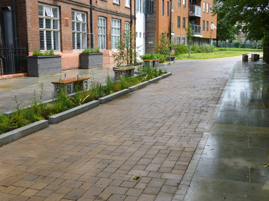
Figure 13: After the community planting day, June 2014
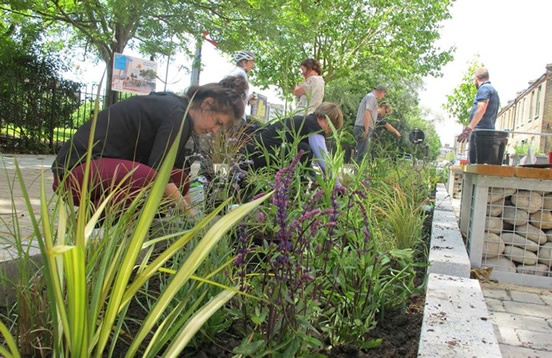
Figure 14: Community planting event
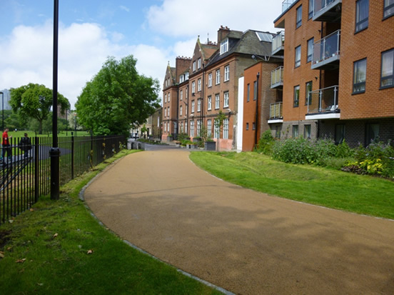
Figure 15: Completed works looking westbound- Swale in foreground, June 2014
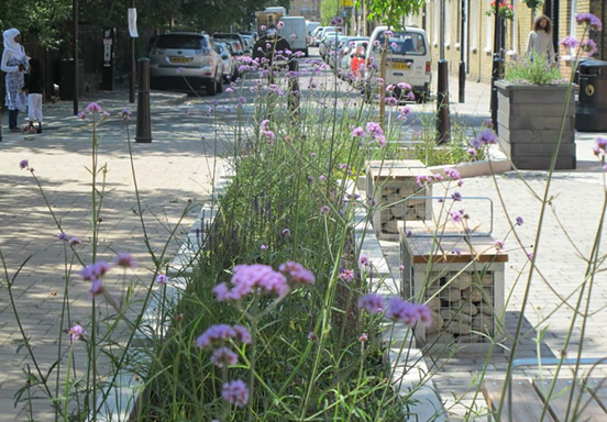
Figure 16: Completed scheme, August 2014
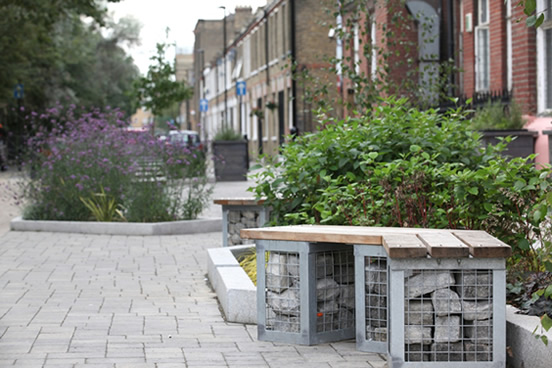
Figure 17: Gabion bench filled with granite setts excavated from the road, August 2014
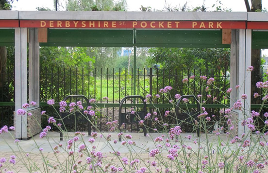
Figure 18: Green roof bike shelter
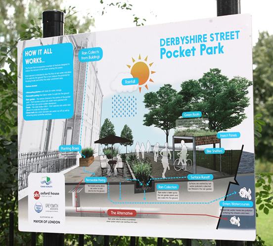
Figure 19: Signage at the pocket park to help explain the scheme
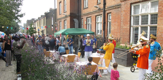
Figure 20: Street Party in the Pocket Park, to Celebrate 130 years of Oxford House


